

There is nothing that can match the feeling of being on a mountain summit, standing on what seems like the top of the world. Here – with peaks and valleys stretching into forever – is one of my favorite places to be. Naming those peaks, however, is not among my strengths. Whether during a summer hike or a winter ski outing, I often wish I knew which mountains make up the view I’m admiring.
Forester Jon Martin introduced me to the PeakFinder app when I visited his family’s Bridgewater, New Hampshire, woodlot about a year ago (see Stewardship Story in the Spring 2023 issue of Northern Woodlands). I asked Jon about a mountain range visible from his height of land. The Sandwich Mountains, he told me – then held up his phone and tapped the screen, which displayed each peak and its name.
During the past summer-into-fall hiking season, I explored the app while on my own mountain forays – and when I was walking through my neighborhood and wanted to put names to some of the hills and mountains I pass by regularly. Along the way, I’ve come to appreciate some of PeakFinder’s fun and informative features.
Here’s how it works. First, simply open the app and hold your phone so the camera is facing the vista of interest. An outline of the landscape’s contours will appear on your screen, with each hill and mountain named. (If the mountains on your phone don’t seem to be lining up with the real-life view, touch the GPS button at the bottom right of your screen, which will sync the app with your location.) This basic use of the app also allows users to “see” the view even during a cloudy day. So, if you find yourself on a socked-in summit, PeakFinder will tell you which mountains you’d be able to see on a clear day.
One fun aspect of the app is the “fly” feature, which provides a bird’s-eye view of what’s on the other side of a mountain you can see from where you are. If you touch a mountain named on the screen, a bird icon shows up at the bottom. Click on that, and the app will “fly” you to the top of that mountain and show you what the view is from there. This means that if I’m standing at the top of North Kinsman in New Hampshire, for instance, I can turn my camera to the northeast and touch Mount Lafayette on the screen, and I’ll be able to see the view from that summit: mountains too numerous to mention! (And if you want to find out what you’d be able to see standing atop one of those too-numerous-to-mention peaks, tap on one of them, then the bird icon, and you can keep flying. To get back to the actual view, simply tap the GPS icon at the bottom right of your screen.)
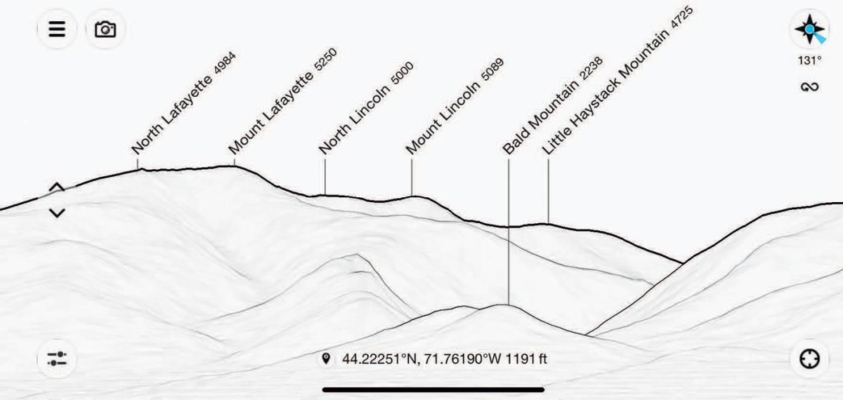
One of my favorite aspects of using PeakFinder is combining the camera mode and snapshot features. With the app open and your phone turned toward the view, touch the camera icon at the top left of the screen to activate your phone’s camera. Line up the outline on your screen to directly overlay the moutains in the frame. Touch the snapshot icon that appears on the middle right of the screen, and your phone will snap a photograph with each mountain labeled. Touch the small photo that appears at the top right of the screen, then the send icon on the lower right, and you’ll be able to save the image to your phone – mountains, labels, and all. I like to use this feature – once I’ve returned from lofty heights to lower ground – to remember which mountains I could see and where I stood in relation to them.
During winter, I tend to reach my mountaintops by chairlift and tramcar. From my most familiar summit of Cannon Mountain, the view on a crystal clear, ultra cold day stretches west to Vermont, east to Maine, and north into Canada. Of all the mountains in that panorama, I can name maybe half a dozen, including a few other ski areas. This season I’m looking forward to using PeakFinder to learn a few more.
For more information and tips on using the app, visit peakfinder.com.